
By Correspondent in Lokoja .

The National Hydroelectric Power Producing Areas Development Commission (N-HYPPADEC) has commenced the desilting of drainages in seven flood-prone Local Government Areas (LGAs) of Kogi State, ahead of anticipated heavy rainfall as predicted by the Nigerian Meteorological Agency (NiMet).
The exercise was flagged off part of proactive measures to mitigate the effects of flooding, which has placed Kogi State on a red alert list by NiMet.
Speaking with journalists in Lokoja, the Acting State Coordinator of N-HYPPADEC, Mr. Michael Omeiza Ajayi, said the initiative follows the 2025 World Environment Day activities earlier launched in the state by the Commission’s Acting Managing Director, Alhaji Haruna Jimoh Gabi.
According to Ajayi, the exercise is being carried out simultaneously in Kogi, Bassa, Adavi, Idah, Ofu, Igalamela, and Lokoja LGAs.
“This is a proactive response to NiMet’s prediction. We are clearing blocked drainage systems to allow for free flow of water into the Rivers Niger and Benue,” he said.
He explained that the project began in Koton Karfe, where the team paid a courtesy visit to the traditional ruler, His Royal Majesty, Alhaji Saidu Akawu Salihu, the Ohimegye of Igu Kingdom, to seek his royal blessings and community support.
Ajayi added that public awareness campaigns are being conducted alongside the desilting to sensitize residents on flood preparedness and hygiene.
“We are working with environmental officers across the seven LGAs to ensure a smooth and effective operation,
“Community involvement is crucial. We are appealing to residents to cooperate with our teams so that we can collectively reduce the impact of flooding in these vulnerable areas,”he said.
He stressed that N-HYPPADEC’s goal is to ensure that flood-prone areas are cleared of debris and silt that block water channels, thereby protecting lives and property.
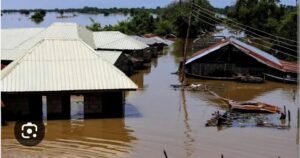
Our correspondent reports that Kogi State remains one of Nigeria’s largely flood-prone states in Nigeria,a reality that has had devastating consequences over the years.
Major flood disasters struck the state in 2012 and again in 2022, wreaking havoc across more than half of its 21 local government areas.
The floods led to the widespread destruction of farmland, homes, and critical infrastructure.
In some communities, lives were tragically lost, while many families were displaced and forced to seek shelter in makeshift camps.
The state’s vulnerability to flooding is largely due to its geographical location at the confluence of the Rivers Niger and Benue.
During heavy rains, these rivers often overflow their banks, inundating low-lying areas and triggering humanitarian crises.
As climate change intensifies weather patterns, experts warn that Kogi—and other riverine states—must take proactive steps, including investment in early warning systems, flood management infrastructure, and sustainable land use practices, to mitigate future disasters.
Edited by Dada Ahmed.

